Maine has many great fresh water fisheries. Bucktail Guide Service concentrates on the fisheries in western and central Maine. Productive rivers such as the Rapid, Kennebago, Kennebec and the Magalloway just to name a few. From the base camp in Rangeley, we will have access to some of the best trout and salmon fishing known in Maine.
Fishing the Wild Rivers of Maine
Selected Locations Include
Magalloway River
Home to large brook trout, brown trout, rainbow trout and landlocked salmon, the Magalloway River begins as three branches in the remote mountainous region of Bowman Town TWP on the Canadian border. It flows for 48 miles through the mixed growth forests once heavily logged into Parmachenee Lake, Aziscohos Lake and ultimately into Umbagog Lake, thus forming the headwaters of the Androscoggin River.
The Upper Magalloway, above Parmachenee Lake and Aziscohos Lake, is located within blocks A1, B1 & C1 on page 28 of the The Maine Atlas and Gazetteer. The river is not dammed, remote, wild, and home to some of the best remote fishing in Maine. The best time to fish the river is when the water temperatures are lower in the spring and the fall. If you do not mind walking, the section of the river between the two lakes, above #10 bridge, off the Parmachenee Road, holds big fish if you want to work for them.
The lower section of the river below Aziscohos Dam is located within block E5 on page 27 of the The Maine Atlas and Gazetteer and is a classic tail-water. Accessible off from Route 16 west of Oquossoc, the river descends 250’ in just two miles. Water temperature remain cold for spring and fall fishing and remains cool that to create good fishing through the hot summer months. This river has it all; fast runs, pocket water, riffles, pools and back eddies. If you like to nymph, this is great water to do so. As the river flows south it slows and widens and becomes long stretches of riffles and cut banks. It flows through meadows and deepens as it passes under the covered bridge. Do not overlook this water, it is fishy and will produce nice sized trout.
Suggested Selected Fly Patterns
Beadhead Prince, Zebra Midge, Eggs, Cased Caddis, Blue-wing Olive, Hendrick Parachute Adams, Black Ghost, Barr Emerger, WD 40, Montreal Whore. Brown and Green drake emerger patterns, Baby Brown trout, Mini Muddlers, Woods Special, Prince Nymphs,Hares ear, Copper Johns in copper, green, pink and black (with or without beadheads)
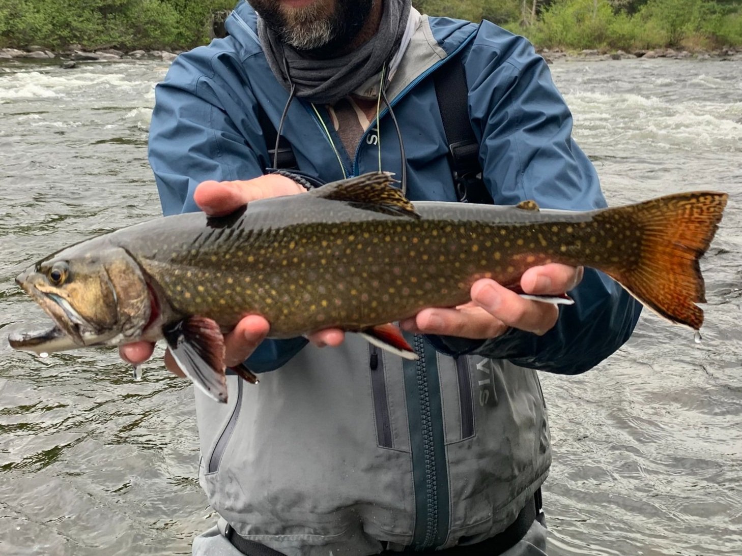
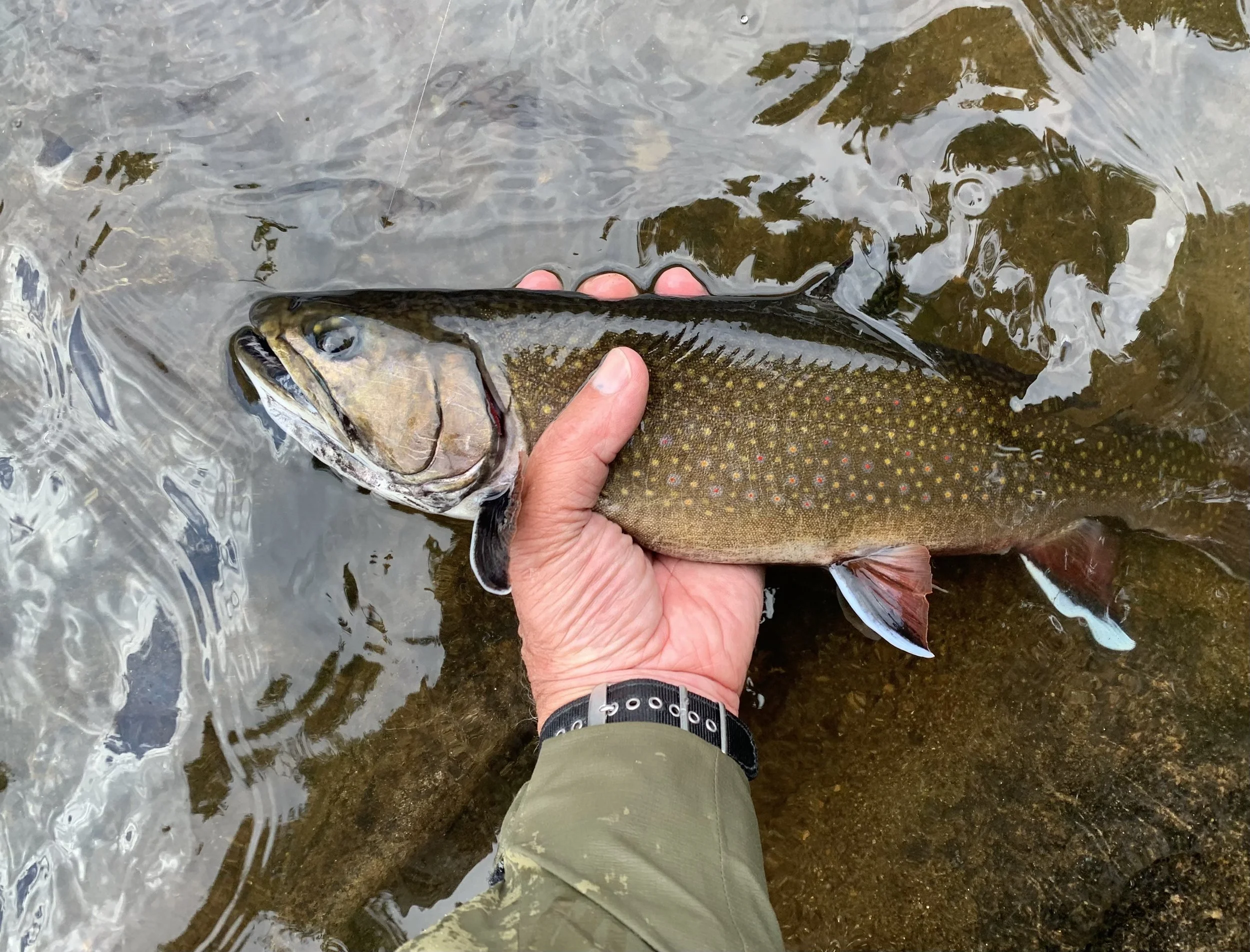
The Dams & Rapid River
There are three dams (Upper, Middle & Lower) that exist on the Richardson Lake watershed which is in Richardsontown, Magalloway PLT and Township C in the western part of Maine. Upper Dam is the dam located between Mooselookmeguntic Lake and Upper Richardson Lake within block A2 on page 18 of the The Maine Atlas and Gazetteer. Historically, the pool and outlet just below the original dam was great fishing with good walk-in access from a nearby parking lot. However, the dam was rebuilt in 2017, the pool and outlet became effected by the construction. Since the end of construction, the fishing is slowly recovering.
Middle Dam is located on Lower Richardson Lake at the head of the Rapid River within block B1 on page 18 of the The Maine Atlas and Gazetteer. The Rapid River runs from the damn to Umbagog Lake on the New Hampshire border. Along the way, the river descends around 160’ over six miles which creates a fast-flowing turbulent river. Slowing the flow up is a body of water known as Pond in the River which is located about a mile below Middle dam. This 512-acre pond brings a cushion into the river flow and provides great fishing at the inlet as well as the lake itself. The Rapid River exists the lake and makes its final 5 mile run to Umbagog Lake.
Lower Dam is located a couple hundred yards down the Rapid River at the outlet of Pond in the River. Once a formidable obstruction, it is now a pile of foundation stones that extends into the river. Great fishing exists from the dam downstream to Umbagog Lake in such locations as Long Pool, Cold Spring and Hedge Hog.
Suggested Selected Fly Patterns
Elk-hair Caddis, brown, gray or olive Klinkhamers, BWO, Cased Caddis, Light Cahil.
Area Map:
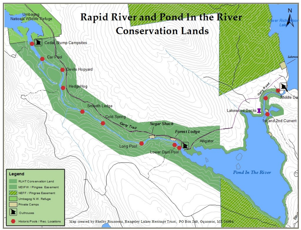
Map created by Shelby Rousseau of Rangeley Lakes Heritage Trust
Rangeley River
The Rangeley River, located within block E3 on page 28 of the The Maine Atlas and Gazetteer, is a fly fishing only river which flows in a westerly direction from Rangeley Lake at Oquossoc to Cupsuptic Lake. Rangeley Lake Dam is located at the head of the river which flows about a mile through land protected by the Rangeley Lake Heritage Trust. Prime locations are located at either end of the river starting at the pool at the base of the dam (known as Bath Tub Pool) and at the inlet into Cupsuptic Lake. Best fished in the spring and the fall, waters warm during the summer to which push trout and salmon back into the lake. Fall rains allow the water temperatures to drop and the fishing improves.
This river is open until October 31st. Prime fishing time is mid- May to mid-June weather and rain dependent. Access is easy down trails from the center of Oquossoc. If “nature” calls while your fishing, a portable sanitation station is located along the way. (That is a fancy way of saying a plastic outhouse is present.)
Suggested Selected Fly Patterns
Copper John & Prince Nymphs, Mayflies, caddisflies, Gray Ghost streamers, and sucker egg patterns.
ORVIS Fishing Report: None
Kennebago River
Offering some of the best fly-fishing opportunities in the greater Rangeley Lakes region, the Kennebago River flows south out of Big Island Pond located within block A3 on page 28 of the The Maine Atlas and Gazetteer. In the remote mountainous region of Seven Ponds TWP east of the Canadian Border, the river (upper section) runs quietly through mixed-growth forests still heavily logged into Little Kennebago Lake then into Kennebago Lake (middle section). From there, the river (lower section) transforms into a classic Maine trout river with pocket water, deep pools, and long runs. It completes its 12-mile journey from Kennebago Lake by flowing into Cupsuptic Lake within the same cove as the inlet of the Rangeley River.
There are two ways to access the river. The land around the lake is managed by Seven Islands and to access fishing spots on the lower river off the entire Kennebago River Rd., you must stay at Grants Camps. To find the gatehouse to the camps, take a right off Rt 16 between Rangeley and Oquossoc on the Boy Scout Rd. Follow the road for about 2 miles you will encounter the gatehouse. You can access the river there at Steep Bank Pool. Drop a canoe there and float down river. The rest of the upstream river is on the other side of the gate. The other way to access the river is to take a right onto the Morton Cut-off Rd. off Rt 16 between Rangeley and Oquossoc. Drive 3.2 miles to the Tim Pond Rd. Take a right onto the Tim Pond Rd. and travel about 8 miles until you cross the Kennebago River (middle). There is a large parking lot on your left to park and access the river at the bridge. A short drive further, take a left on the Kennebago River Rd. to access the upper part of the river.
The upper section of the river above Little Kennebago Lake, is a meandering stream with a few isolated riffs and runs. The banks are lined with heavy and dense alder growth with openings every so often. Accessed off the Kennebago River Road, one can enter the river in several locations. A few miles up the road gates block the access road, so walking will be necessary to fish the upper section of the river. Hot spots are the inlet at Little Kennebago Lake and a rock bar in the lake towards the south end of the lake.
Suggested Selected Fly Patterns
Black & Gray Ghost, Nine Three, Kennebago Smelt, Yellow Wiggle, Scuds, Hares Ear, Adams, Royal Wulff, Golden Stones.
The middle section of the river is sandwiched between Little Kennebago and Kennebago Lakes. The stream is like the upper section of the river meandering through patches of alder growth with gravel rock bars and slow current. However, do not overlook the Warden’s Pool upstream from the bridge and the Devil’s Elbow Pool downstream about ¾ mile.
Suggested Selected Fly Patterns
Black Dace, Nine Three, Yellow Wiggle, Damsel Fly Nymphs, Dragon Fly Nymph, Light Hendrickson, Light Cahill.
The lower section of the river starting at the dam at the outlet of Kennebago Lake is the part of the river that is accessed beyond the gatehouse. Known for its 23 pools, it is characterized by fast current moving over and around large rocks and ledges, narrow riffs, long runs and pocket water between the pools. Fishing is excellent during the early spring into June, then picks back up again during the fall when water temperatures drop.
Suggested Selected Fly Patterns
Gray Ghost, Improved Stone, Black Cricket, Hare’s Ear, Red Fox Hornberg, Tan Caddis, Kennebago Smelt, Nine Three.
ORVIS Fishing Report: None